Showing posts with label NRHP. Show all posts

Thursday, September 1, 2016

Acoma Sky City Cultural Center and Haak'u Museum

Aerial View of Sky City
photo by Marshall Henrie for Wikimedia Commons

Name: Acoma Sky City Cultural Center and Haak'u Museum
Tribe: Pueblo of Acoma
Location: Haaku Road, Pueblo of Acoma, NM 87034
Type: Historic Site, Cultural Center/Museum, Cafe, Gift Shop
Visiting Info: Open daily, 8am-5pm, call for museum hours and tour time registration
Contact: Website, telephone 800-747-0181

The Acoma Pueblo, perched on the top of a 367 ft. high mesa in the New Mexico desert, is one of the oldest continually inhabited settlements in North America. It is approximately 2,000 years old and is home to the San Esteban del Rey Mission church which was completed in 1640. Both the mission and the pueblo are on the National Register of Historic Places and are a site of the National Trust for Historic Preservation.

Sky City Cultural Center
photo from Wikimedia Commons

At the base of the mesa sits the Acoma Sky City Cultural Center and Haak'u Museum building and visitor parking. The Museum offers permanent and rotating exhibits focusing on Pueblo history and the preservation of Puebloan art, specifically Acoma's famous pottery. The 40,000 sq. ft. Cultural Center complex includes the Y'aak'a Cafe, which serves traditional Acoman and contemporary southwestern cuisine, the Ts'ikinum'a Theater showing short films on Pueblo history and culture, meeting/event space with catering options, and the Gaits'i Gift Shop.

photo from Sky City Casino Hotel webpage

Tours of the Pueblo itself are available daily from the Cultural Center, from 8am to 5pm, but it seems best to call ahead (1-800-747-0181) and register for a tour time and to verify current open hours for the Cultural Center's facilities. The pueblo is continually inhabited by a small group of tribal members, and as such, there are sensitivity issues involved with touring the village. The Acoma people ask that dress should be modest (and mindful of the sometimes extreme weather), pets and smoking are prohibited, and photography is not allowed without a permit. Please read the visitor etiquette page. The tours last an hour and a half and cost $23 for adults, $15 for children. Group tours, family rates, and shorter tours of the mission only are also offered.

San Esteban del Rey Mission
photo from Ken Schneider, Flickr's Creative Commons

The Pueblo people celebrate annual feast days that are related to their specific pueblo and mission saint. The feast day of San Esteban is celebrated at Sky City on September 2nd. If you plan to attend, be sure to read up on the specific etiquette rules before you go. Every year in September the Acoma Pueblo also hosts the Tour de Acoma, a series of 25-, 50-, and 100-mile desert bike races. There is also a Luminaria Celebration and dances at the mission church around Christmas. Check the calendar for special events and annual closed days at the pueblo before you schedule your trip.

Sky City is about 70 miles west of Albuquerque and a ways off of I-40, but the Acoma do have a casino hotel and an RV park directly off of the interstate, and they offer big game hunting tours on the reservation in the Fall. Cibola County is also home to the longest uninterrupted stretch of historic Route 66 in New Mexico, which runs immediately to the north of the Casino as State Highway 124.

Tuesday, July 19, 2016

Boston Harbor Islands

Boston skyline from Spectacle Island

Name: Boston Harbor Islands
Tribe: Nipmuc, Massachusett, Wampanoag, Pokonoket
Location: Boston, MA
Type: National Park, State Park
Visiting Info: May-October, Ferry Schedules; Ferry tickets: $10-17, round trip.
Contact: Website, telephone ("Ask a Ranger") 617-223-8666

"Histories and other studies prepared by and with American Indians are needed in order to adequately present Indian connections with the islands. In that those studies are not complete, the following sketch is offered to introduce the complex Native American topics associated with the park."

So begins the National Park Service's webpage about the Native history of the Boston Harbor Islands. The document gives an overview of the seasonal use of the harbor before European colonization and tells about the later forced removal and imprisonment of Natives on the islands after King Phillip's War.

The main prison camp was located on Deer Island, but there is evidence that Native people were also relocated to Peddocks, Long Island, and possibly one of the Brewster Islands. Records show that about half of the people died of starvation, exposure, and illness over the winter of 1675.

Today, as with so much of Indian Country, incredible beauty intermingles with historical horror. The islands, and the harbor itself, have been cleaned up and rejuvenated for public use after decades of environmental degradation. The area is both a state park and a national park and is managed in cooperation by several different agencies. More than 30 islands offer a variety of recreational opportunities and are served by a fairly extensive ferry service.

Hiking trail along the shore of Deer Island overlooking Boston

The park includes three National Historic Landmarks: Long Wharf, Fort Warren, and the 300-year old Boston Light, which is the oldest lighthouse station in the US. Spectacle Island offers a swimming beach, there's camping on Grape, Lovell, Bumpkin, and Peddocks Islands, hiking trails on most of the islands, a marina, and lots of other tours and activities.

The ferry leaves from Long Wharf in downtown Boston (also from ferry docks in Hingham and Hull, MA) and goes to Georges, Spectacle, Peddocks, Lovells, Thompson, Grape, and Bumpkin Islands. You can also make hops between islands if you go early and plan your day carefully. Deer and Nut Islands, Webb Memorial Park, and World's End are accessible by car year-round. Little Brewster Island, home of the Boston Light station, is available only on Ranger-led tours.

Planning for a Native American Memorial is underway, with a site dedicated on Deer Island and a sculpture commissioned from Native artist Lloyd Gray–Nessatako (Mohawk Iroquois of the Onondaga People). There is currently a plaque and signage in place that gives a brief history of the island as a concentration camp.

A model of the proposed Memorial statue by Mohawk sculptor Lloyd Gray-Nessatako.
photo from nps.gov

A display in the Visitors' Center on Spectacle Island and informational signage on Peddocks Island also briefly present Native history and life on the islands.

Additionally, the National Park Service sponsored an award-winning video series called Living in Two Worlds: Native American Voices on the Boston Harbor Islands. Representatives of the Nipmuc, Massachusett, and Wampanoag tribes give the Native history of Eastern Massachusetts and the Harbor Islands and demonstrate preservation efforts and the resilience of living Native communities in New England today.


Resources:

Tuesday, September 22, 2015

Five Civilized Tribes Museum


Name: The Five Civilized Tribes Museum
Tribe: Muscogee (Creek), Cherokee, Choctaw, Chickasaw, Seminole
Location: 1101 Honor Heights Drive, Muskogee, OK 74401
Type: Art and History Museum, NRHP Historic Building
Visiting Info: Mon-Fri 10am-5pm, Sat 10am-2pm (closed Sundays and all of January), Admission: $1.50-$3
Contact: Website, telephone 918-683-1701

In 1951, a Native women's organization called the Da-Co-Tah Club began a campaign to turn the abandoned Union Indian Agency Building in Muskogee, Oklahoma, into a museum.

The Club's mission since its establishment in the 1930s was to create an intertribal organization to raise awareness of Native history and communities, foster better communication between Nations, strengthen social ties, and meet the needs of their underserved population.

Throughout the Dust Bowl and the Second World War, the Da-Co-Tah women raised money for the Murrow Orphanage, the Drought Relief Fund, the Unemployment Fund, and the Salvation Army, as well as providing services for impoverished children and Native families.

Out of their desire to celebrate Native identity and encourage intertribal cooperation, they envisioned a museum that would showcase the cultures and art of the Five Civilized Tribes of Oklahoma - the Cherokee, Muscogee (Creek), Choctaw, Chickasaw, and Seminole - together. And as part of their vision, they would preserve the building that had once housed the Bureau of Indian Affairs' Superintendent of the Five Civilized Tribes in Indian Territory. The building itself would commemorate the terrible history of the Removal period, the Trail of Tears, and the struggles and survival of the Five Tribes in Oklahoma afterward.

During the 20th century, the Agency Building had passed from the BIA to the Muscogee (Creek) Nation who used it as a school for Creek Freedmen. The Creeks gave it to the city of Muskogee in 1909 as part of Honor Heights Park, and then the city gave it back to the federal government during WWII to be part of the veteran's hospital complex that still stands next door. Seeking to transfer the building back to the town of Muskogee, the Da-Co-Tah Club sponsored a bill in the US House of Representatives with Muskogee-born US Rep. Ed Edmonson in 1954.

The House Bill was signed by President Eisenhower in 1955, the building was restored entirely by privately donated funds raised by the Club, and the Museum was opened in 1966.

Today, the Five Civilized Tribes Museum displays historical exhibits on the ground floor and its art collections upstairs. Many of the Five Tribes' most famous artists have pieces on view, and the Museum owns the world's largest collection of works by Jerome Tiger (Muscogee Creek-Seminole). There is a library and archive upstairs, but it is open by appointment only.

The Museum hosts a yearly Masters Art Show in November and a Student Art Show (grades 7-12) in March. The "Art Under the Oaks" Art Market happens in April, around the time of the Azalea Festival in the adjoining Honor Heights Park.

Friday, September 11, 2015

Ocmulgee National Monument

Stairs up the Great Temple Mound
photo from Wikimedia

Name: Ocmulgee National Monument
Tribe: Mississippian and Lamar cultures, Muscogee (Creek)
Location: 1207 Emory Highway, Macon, GA 31217
Type: National Park, prehistoric mounds, hiking trails, museum, events
Visiting Info: Open daily, 9am-5pm, Admission is free except for special events
Contact: Website, telephone 478-752-8257

The Ocmulgee National Monument, located on the Ocmulgee River in Macon, GA, preserves 702 acres of prehistoric mounds and other earthworks built on a site that has been inhabited by Native people for an estimated 17,000 years. The site came under the protection of the National Park Service in 1934 and was placed on the National Registry of Historic Places in 1966.

Although people have been living and hunting along the river since the last Ice Age, the seven mounds located in the park were built by the South Appalachian Mississippian people around 900 AD. The largest earthwork is the Great Temple Mound, which is 55 feet high and has a wooden stairway that visitors can climb to take in the view from the top. Nearby is the Lesser Temple Mound, and the park also includes a burial mound, other small ceremonial mounds, and defensive earthwork trenches.

Park Map via NPS

In addition to the mounds, the park includes six miles of hiking and biking trails, fishing and picnicking areas, and an 800 foot long boardwalk over wetlands. There is also a historic railroad bridge, some civil war era landmarks, the historic site of an English colonial trading post from 1690, and a reconstructed ceremonial earthlodge, the floor of which is the original one thousand year old floor of a Mississippian earthlodge.

Two more mounds and the remains of a palisade and village are located three miles away at the Lamar Mounds and Village Site. The Lamar culture developed after the decline of the Mississippian culture around 1300 AD. The Lamar site is part of the Ocmulgee National Monument park but is accessible only by a park ranger-guided tour and four mile roundtrip hike (call 478-752-8257 for details and reservations).

Ocmulgee Visitor Center
photo from ONMA

Inside the striking, terracotta and white art moderne Visitor Center, there is a gift shop and a small theater area presenting a short orientation film, "Mysteries of the Mounds." An archaeology museum displays thousands of artifacts from excavations that have taken place onsite. Other exhibits detail the history of the Ocmulgee River location, including the rise of the Muscogee (Creek) Confederacy from the descendants of the Lamar people whose culture and population was decimated by disease spread by Hernando de Soto's expedition in 1540.

photo from ONMA on Facebook

Two special events are held at the ONM each year, the Lantern Light Tours in March and the Ocmulgee Indian Celebration in September. The Ocmulgee Indian Celebration is the largest Native gathering in the Southeastern United States and represents all the tribal nations from the region through hundreds of craftspeople and music, dance, food, storytelling, and more.


Friday, July 17, 2015

Cherokee Heritage Center

photo from visitcherokeenation.com

Name: Cherokee Heritage Center
Tribe: Cherokee Nation, United Keetoowah Band of Cherokee Indians
Location: 21192 S. Keeler Drive, Park Hill, OK 74457
Type: Cultural Heritage Complex
Visiting Info: Open year round, Summer (Memorial Day through Labor Day) Mon-Sat, 9am - 5pm, Winter (except Jan 1-14: closed) Tues-Sat, 9am - 5pm; Admission: $5-$8.50.
Contact: Website, telephone 888-999-6007
 
The Cherokee Heritage Center is a complex of attractions that includes the Cherokee National Museum, the Trail of Tears exhibit, Diligwa -  The 1710 Cherokee Village, Adams Corner Rural Village, Nofire Farms, the Cherokee Family Research Center, and the Cherokee National Archives.

The Center also offers special exhibits, cultural workshops, and events, including the Cherokee National Holiday celebration, the Trail of Tears Art Show and Sale, and the Homecoming Art Show.

Trail of Tears Exhibit
photo from cherokeeheritage.org

Artifacts, cultural objects, and art pieces from the span of Cherokee history are on display in the Museum and the Trail of Tears exhibit.

The Diligwa village depicts a traditional Cherokee settlement in the 18th century prior to assimilation. Docents guide visitors through the encampment, explaining traditional culture, crafts, hunting techniques, and games. The self-guided Adams Corner Rural Village and Nofire Farms show what tribal towns looked like after assimilation and the horrors of the Trail of Tears. Set in the 1890's, the seemingly bucolic Rural Village presents the turmoil faced by the Cherokee as Indian Territory began its transition to Oklahoma statehood.

The Swimmer School at the Adams Corner Rural Village
photo from cherokeeheritage.org

The Heritage Center is also home to the Cherokee National Archives, and admission to the complex provides visitors with access to the Cherokee Family Research Center and their genealogical resources. Staff are available to help researchers access Dawes Commission records and the Final Rolls, Seminary records, Cherokee cemetery documentation, and citizenship resources.

The Center is located just to the south of Tahlequah, the Cherokee Nation's capitol, on the grounds of the original Cherokee Female Seminary in an old settlement called Park Hill. The spot is of great historic significance as Park Hill was the home of many important tribal leaders, such as John Ross, in the period after the Removal, and the Seminary was the first educational institution for women west of the Mississippi River.

Park Hill is also home to the John Ross Museum, Ross Cemetery, and the Murrell Home.


Resources:

Monday, June 8, 2015

Medicine Wheel: To Go or Not to Go?


Before I saw this tweet, I had never heard of the Bighorn Medicine Wheel. I've never been to Wyoming and am not terribly familiar with these physical medicine wheel constructions on the northern plains. But 700 years is significant, this photo looks almost unreal, and the "most sacred site for Native Americans" part makes me nervous, so I was curious to find out the real story on this place.

The Medicine Wheel National Historic Landmark is a fascinating place, especially for someone like me with anthropology/archaeology and history degrees and a strong interest in Native culture. But for someone (again, like me) who is writing a travel blog encouraging people to go learn about and experience Native America, a bunch of red flags also started waving in my head. While the Wheel is in a National Forest that welcomes visitors and does have interpreters onsite in the summer, it is a sacred and protected place. Should a non-Native traveler like me go there? Should we just stay away out of respectfulness?

The Medicine Wheel is located near the summit of Medicine Mountain in the Bighorn National Forest near Lovell, Wyoming. It has been used by Northwest Plains tribes such as the Arapaho, Cheyenne, Crow, Lakota, Dakota, Shoshone, Cree, Salish, Kootenai and Blackfeet for hundreds of years as a ceremonial location. Archaeologists believe that the surrounding area of connected sites has been in use by humans for more than 7,000 years. Between 70 and 150 similar medicine wheels have been found in South Dakota, Wyoming, Montana, Alberta, and Saskatchewan, but the Medicine Mountain wheel is one of the best preserved and most typical.

It was added to the National Register of Historic Places (NRHP) as a National Historic Landmark (NHL) in 1969 and renamed Medicine Mountain National Historic Landmark (from Bighorn Medicine Wheel) in 2011. Unfortunately, the Forest Service has not had a strong history prior to these most recent agreements of partnering with Native tribes to protect the integrity of the area as a sacred place and ensure the peoples' rights to use the site for ceremonial purposes. In 1988, a Forest Service plan to expand tourism to the area was blocked by a coalition of indigenous, environmental, and historical-preservation groups who felt the plan was too exploitative.

That action resulted in a 1996 Historic Preservation Plan which currently mandates unlimited tribal ceremonial use and carefully managed, restricted tourism. Native American interpreters guide visitors when the site is not in use for ceremonies, and there is a 1.5 mile hike to the Medicine Wheel in order to minimize vehicle traffic. Legal action has been taken to prohibit or limit natural resources extraction, such as logging and grazing.

So, should you and I make the hike up Medicine Mountain to visit the Medicine Wheel if we find ourselves in the area? Does it make a difference that I am white? What about a member of another tribe from elsewhere in America who might be on vacation there, such as a Choctaw or a Mohegan citizen? What about a practitioner of some New Age religion who wants to visit the site as a "pilgrim?"

I don't know what the answers are. As my mouse hovered over that original tweet, I questioned whether it was the right thing to do. And I decided not to hit retweet.

Resources:

Wednesday, May 20, 2015

Cahokia Mounds State Historic Site

photo credit: Ira Block, National Geographic Creative

Name: Cahokia Mounds State Historic Site
Tribe: Pre-Columbian Mississippian Culture
Location: Collinsville, IL
Type: UNESCO World Heritage Site, National Historic Landmark, Museum
Visiting Info: Open year-round, Grounds: 8am - dusk, Interpretive Center: varies by season, Free admission with suggested donation of $2 - $15.
Contact: Website, telephone 618-257-3441

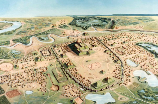
More than 1,000 years ago, a city of about 15,000 indigenous people rose up above the central plains near the Mississippi River. With over six square miles of mounds and temples, agricultural fields and homes, it was an urban hub of the vast trading network of the Mississippian people that lived on this land before European contact.

Archaeologists and historians call it Cahokia, and it was probably the largest and most influential Mississippian community. Today it is the most complex archaeological site north of the much more famous remains of the pre-Columbian empires of Mexico.

The Cahokia Mounds State Historic Site, located just to the east of St. Louis, contains 80 of the more than 120 original mounds, a central plaza for ceremonies and games, a reconstructed woodhenge, remains of stockades and palisades, and a copper workshop.

Painting by William R. Iseminger, from this Cahokia photo gallery

The Interpretive Center displays artifacts, an introductory video presentation, and a recreation of the original village. Exhibits aim to educate the public about the Mississippian culture and the archaeological work that is going on at the site.

Guided and self-guided tours of the mounds and trails are available.


Resources:
Aerial video of Cahokia from chickasaw.tv
IHPA Introductory Video
Mississippian Culture Wikipedia article
National Geographic web article May 19, 2015, "New Evidence May Solve Mystery of America's Huge Ancient City."

Monday, May 4, 2015

Aquinnah Cultural Trail and Aquinnah Cultural Center


Name: Aquinnah Cultural Trail, including the Aquinnah Cultural Center
Tribe: Wampanoag Tribe of Gay Head (Aquinnah)
Location: Martha's Vineyard (Noepe), Aquinnah Cultural Center: 35 Aquinnah Circle, Aquinnah, Massachusetts, 02535
Visiting Info: Aquinnah Cultural Center is open Wed., Fri., Sat., 11 am - 4 pm, Admission $3-$5.
Contact: Website, telephone 508-645-7900

When most people think of Martha's Vineyard, they imagine rich people in boat shoes and khaki pants embroidered with whales eating lobster dinners by the sea. But the Wampanoag people who live on the island they call Noepe have a different experience to offer visitors. The tribe's website lists special places of interest on a self-guided tour around the island called Wampanoag Way: an Aquinnah Cultural Trail.

The Trail's wide variety of destinations range from the Aquinnah Cliffs, which are the home of Moshup the Giant (from Wampanoag oral history) and a sacred place for the tribe and protected National Historic Landmark, to the Gay Head Community Baptist Church which is on the National Registry of Historic Places, to the shipwreck of "The City of Columbus" at Devil's Bridge, to the Felix Neck Wildlife Sanctuary, to the tribally-owned Alley's General Store in West Tisbury.

The points of interest provide a picture of the tribe's history on the island, cultivating cranberries and cattle, fishing for herring and eels, and whaling. The website tells the stories of many of the island's place names, such as Tashmoo the swift runner, namesake of Tashmoo's Overlook and Lake, the love story of Katama and Mattakesset, and the tale of Moshup throwing a crab into the sea to make the island of Noman's Land which became the home of the sachem Tequenoman. The Trail also depicts the tribe's interactions with English and American settlers and missionaries over the past four centuries, including their harboring of escaped slaves and Quakers at Vineyard Haven.

The Wampanoag people of Massachusetts belong to two federally recognized tribes (and several other state-recognized bands and tribes): the Mashpee Wampanoag on the Cape Cod mainland and the Wampanoag Tribe of Gay Head (Aquinnah) on the island.

Gay Head was the name of the town on the southwest end of Martha's Vineyard until 1997 when the community there, which is home to most of the tribe, voted to change it to its traditional name of Aquinnah. The two place names continue to overlap, although it seems like Aquinnah is slowly taking over.

One of the stops on the Trail is the Aquinnah Cultural Center. The Center is located on the Aquinnah Cliffs in the Edwin Vanderhoop homestead, which was built in the 1890's and restored in 2006. The Center offers tours of the home and its collections. They also host cultural events through the summer months (June-August), including the Annual Feast and Fundraiser and a yearly Native American Artisan's Festival. The Aquinnah Lighthouse is nearby, and the Cultural Center offers a combo admission price.

Transportation to the island and around it is a challenge and the accommodations are expensive, especially in the summer. Ferries carry passengers and cars to the island year-round from several ports up the New England coast, but bringing your own car is pricey and there are fewer tickets. The ferries land on the northeast side of the island, away from Aquinnah, but there is a bus service around the island, taxis, and car and bike rentals. If you go in summer, you will need to get a rental reservation early as they book up fast.


Resources:
Wampanoag Tribe of Gay Head Aquinnah
Aquinnah Cultural Center on Facebook
Gonomad.com article from 2010, "Martha's Vineyard: Homeland of the Wampanoags"
Boston Globe article from June 21, 2014, "The List: Native American-owned businesses on Martha's Vineyard."
Martha's Vineyard Magazine article from July 1, 2013, "Cultural Outpost" (list of native-owned businesses)

Friday, May 1, 2015

Old Indian Meeting House


Name: Old Indian Meeting House or Old Indian Church
Tribe: Mashpee Wampanoag
Location: 410 Meetinghouse Road, Mashpee, Massachusetts, 02649
Type: Historic Building, National Register of Historic Places
Visiting Info: By appointment or seasonal events
Contact: Website, telephone 508-477-0208 x101

A postcard photo of the Church from 1905

Originally built in 1684 on the site of an even older Mashpee church, the Old Indian Meeting House is the oldest Native American church in the Eastern US and the oldest church on Cape Cod. The Mashpee Revolt led by minister William Apess occurred here in 1833. Even though it is a reminder of the complicated relationship between Native tribes and Christianity, it has functioned as a church, a gathering place, a school, and a burying ground for the tribe for more than 300 years.


The Meetinghouse is open for annual events such as Native New Year (May), Ancestor's Day (September), and Native American Thanks Giving (November), hosted by the Old Indian Meeting House Committee of the Mashpee tribe.


Resources:
Mashpee Wampanoag Tribe
Wikipedia article, "Old Indian Meeting House"
Mashpee Enterprise news article from Dec. 2009, "Mashpee Old Indian Meetinghouse Reopened"
Restoration photos at Keenan + Kenny Architects, Ltd., webpage
Cape Cod Times news article from Dec. 2009, "Mashpee tribe reopens meetinghouse"